Geolocate

Salang topographic map

Click on the map to display elevation.

About this map

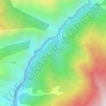
Name: Salang topographic map, elevation, terrain.

Location: Salang, Bhatwari, Uttarkashi District, Uttarakhand, India (30.82213 78.61557 30.86213 78.65557)

Average elevation: 7,126 ft

Minimum elevation: 5,180 ft

Maximum elevation: 10,771 ft

Other topographic maps

Click on a map to view its topography, its elevation and its terrain.

Pari Maatri Taal

India > Uttarakhand > Bhatwari

Average elevation: 14,577 ft

Kedar Tal

India > Uttarakhand > Bhatwari

Average elevation: 15,794 ft

Kyarkoti Lake

India > Uttarakhand > Bhatwari

Average elevation: 13,264 ft

Harsil

India > Uttarakhand > Bhatwari

Average elevation: 9,058 ft

Kalindi Khal Area

India > Uttarakhand > Bhatwari

Average elevation: 19,216 ft

Gangotri Glacier

India > Uttarakhand > Bhatwari

Average elevation: 17,254 ft

Kedar Tal

India > Uttarakhand > Bhatwari

Average elevation: 15,794 ft

Harsil

India > Uttarakhand > Bhatwari

Average elevation: 9,058 ft

Dayara Bugyal

India > Uttarakhand > Bhatwari

Average elevation: 11,322 ft

Gangotri Glacier

India > Uttarakhand > Bhatwari

Average elevation: 17,254 ft

Gear up for your next adventure:

🔦Compact Flashlight - Reliable flashlight for emergencies
🧥Men's Rain Shells - Premium waterproof and breathable jackets for mountain weather
🛡️Insect Repellent - Protection against bugs during outdoor activities
🧭Outdoor Navigation Book - Learn advanced navigation skills
🪶Thermal Camp Blanket - Extra warmth for cold nights

As an Amazon Associate, this site earns from qualifying purchases at no extra cost to you.