
Make a donation
Gear up for your next adventure:
As an Amazon Associate, this site earns from qualifying purchases at no extra cost to you.
Oetinghauser Heide topographic map
Click on the map to display elevation.
Make a donation
Gear up for your next adventure:
As an Amazon Associate, this site earns from qualifying purchases at no extra cost to you.
About this map
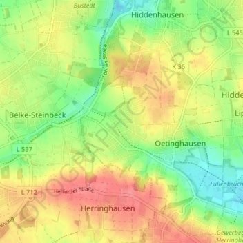
Name: Oetinghauser Heide topographic map, elevation, terrain.
Average elevation: 325 ft
Minimum elevation: 213 ft
Maximum elevation: 436 ft
Make a donation
Gear up for your next adventure:
As an Amazon Associate, this site earns from qualifying purchases at no extra cost to you.
Other topographic maps
Click on a map to view its topography, its elevation and its terrain.
Oetinghausen
Deutschland > Nordrhein-Westfalen > Kreis Herford > Hiddenhausen
Average elevation: 325 ft
Lippinghausen
Deutschland > Nordrhein-Westfalen > Kreis Herford > Hiddenhausen
Average elevation: 318 ft
Eilshausen
Deutschland > Nordrhein-Westfalen > Kreis Herford > Hiddenhausen
Eilshausen war eine Siedlung, die sich zu einem westfälischen Angerdorf entwickelte. Es ist zu vermuten, dass die Höfe einmal dicht am Wiesenbach gelegen haben, da die früher hier betriebene Spinnerei eine feuchte Luft erfordert. Später sind sie höher hinaus und an andere Ortsstellen verlegt worden. Nach…
Average elevation: 344 ft