
Lolland topographic map
Interactive map
Click on the map to display elevation.
About this map
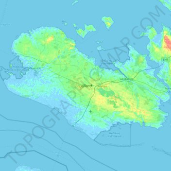
Name: Lolland topographic map, elevation, terrain.
Location: Lolland, Lolland Kommune, Región de Selandia, Dinamarca (54.59375 10.95471 54.96074 11.86672)
Average elevation: 7 ft
Minimum elevation: -20 ft
Maximum elevation: 125 ft
Other topographic maps
Click on a map to view its topography, its elevation and its terrain.
Snap-ind
Dinamarca > Región de Selandia > Snap-ind
Snap-ind, Lolland Kommune, Región de Selandia, 4941, Dinamarca
Average elevation: 13 ft
Falster
Dinamarca > Región de Selandia
Falster, Guldborgsund Kommune, Región de Selandia, Dinamarca
Average elevation: 10 ft