
Slabtown topographic map
Click on the map to display elevation.
About this map
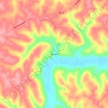
Name: Slabtown topographic map, elevation, terrain.
Location: Slabtown, Henry County, Kentucky, 40007, United States (38.41285 -85.02523 38.45285 -84.98523)
Average elevation: 719 ft
Minimum elevation: 449 ft
Maximum elevation: 879 ft
Henry County trails, hiking, mountain biking, running and outdoor activities
Other topographic maps
Click on a map to view its topography, its elevation and its terrain.
Eminence
United States > Kentucky > Henry County
According to the United States Census Bureau, the city of Eminence has a total area of 2.9 square miles (7.4 km2), of which 0.04 square miles (0.1 km2), or 1.70%, is water. The city is located on high ground, with elevations up to 960 feet (290 m), where several watersheds converge. The source of the Little…
Average elevation: 899 ft