Geolocate

Kanker topographic map

Click on the map to display elevation.

Kanker

Kanker is located at 20°16′N 81°29′E / 20.27°N 81.49°E / 20.27; 81.49. It has an average elevation of 388 metres (1272 feet).

Wikipedia (CC-BY-SA 3.0)

About this map

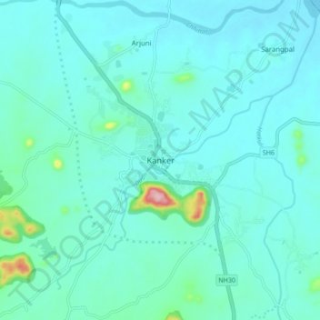
Name: Kanker topographic map, elevation, terrain.

Location: Kanker, Kanker Tahsil, Uttar Bastar Kanker, Chhattisgarh, 494334, India (20.22927 81.45321 20.30927 81.53321)

Average elevation: 1,329 ft

Minimum elevation: 1,240 ft

Maximum elevation: 1,952 ft

Gear up for your next adventure:

GPS Sports Watch - GPS watch for running, hiking and training
⛑️Personal Locator Beacon - Safety beacon for emergencies
🛠️Backpacking Tool Kit - Essential toolkit for outdoor repairs
🎒Gear Packing Cubes - Organize your backpack efficiently
🪶Paracord Bracelet - Survival bracelet with built‑in tools

As an Amazon Associate, this site earns from qualifying purchases at no extra cost to you.