
Make a donation
Gear up for your next adventure:
As an Amazon Associate, this site earns from qualifying purchases at no extra cost to you.
Rankenhohn topographic map
Click on the map to display elevation.
Make a donation
Gear up for your next adventure:
As an Amazon Associate, this site earns from qualifying purchases at no extra cost to you.
Rankenhohn
Alzenbach | Bach | Balenbach | Baleroth | Baumhof | Bitze | Blumenhof | Bohlscheid | Bourauel | Bruch | Büsch | Büsch bei Merten | Eitorf | Halft | Hatzfeld | Hausen | Heckerhof | Hohn | Hönscheid | Irlenborn | Josefshöhe | Käsberg | Kehlenbach | Keuenhof-Hove | Köttingen | Kreisfeld | Lascheid | Leye | Lindscheid | Lützgenauel | Merten | Mierscheid | Mittelottersbach | Mühleip | Nannenhohn | Nennsberg | Niederottersbach | Obenroth | Obereip | Obereiper Mühle | Oberottersbach | Plackenhohn | Rankenhohn | Rodder | Rosenthal | Scheidsbach | Schellberg | Schellenbruch | Schmelze | Siebigteroth | Stein | Wassack | Weiden | Wilbertzhohn | Wilkomsfeld
Make a donation
Gear up for your next adventure:
As an Amazon Associate, this site earns from qualifying purchases at no extra cost to you.
About this map
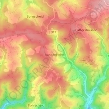
Name: Rankenhohn topographic map, elevation, terrain.
Average elevation: 745 ft
Minimum elevation: 358 ft
Maximum elevation: 1,007 ft
Make a donation
Gear up for your next adventure:
As an Amazon Associate, this site earns from qualifying purchases at no extra cost to you.
Other topographic maps
Click on a map to view its topography, its elevation and its terrain.
Keuenhof-Hove
Deutschland > Nordrhein-Westfalen > Rhein-Sieg-Kreis > Eitorf
Alzenbach | Bach | Balenbach | Baleroth | Baumhof | Bitze | Blumenhof | Bohlscheid | Bourauel | Bruch | Büsch | Büsch bei Merten | Eitorf | Halft | Hatzfeld | Hausen | Heckerhof | Hohn | Hönscheid | Irlenborn | Josefshöhe | Käsberg | Kehlenbach | Keuenhof-Hove | Köttingen | Kreisfeld | Lascheid | Leye |…
Average elevation: 735 ft