
Thank you for supporting this site ❤️
Make a donation
Make a donation
Gear up for your next adventure:
As an Amazon Associate, this site earns from qualifying purchases at no extra cost to you.
Kekri topographic map
Click on the map to display elevation.
Thank you for supporting this site ❤️
Make a donation
Make a donation
Gear up for your next adventure:
As an Amazon Associate, this site earns from qualifying purchases at no extra cost to you.
About this map
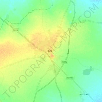
Name: Kekri topographic map, elevation, terrain.
Location: Kekri, Kekri Tehsil, Ajmer District, Rajasthan, 305404, India (25.93421 75.11457 26.01421 75.19457)
Average elevation: 1,158 ft
Minimum elevation: 1,112 ft
Maximum elevation: 1,201 ft
Thank you for supporting this site ❤️
Make a donation
Make a donation
Gear up for your next adventure:
As an Amazon Associate, this site earns from qualifying purchases at no extra cost to you.