Geolocate

Tembali topographic map

Click on the map to display elevation.

About this map

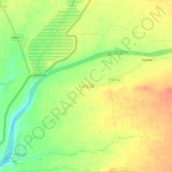
Name: Tembali topographic map, elevation, terrain.

Location: Tembali, Shahade, Nandurbar, Maharashtra, India (21.56952 74.48931 21.60952 74.52931)

Average elevation: 528 ft

Minimum elevation: 436 ft

Maximum elevation: 594 ft

Gear up for your next adventure:

🔦Compact Flashlight - Reliable flashlight for emergencies
Camping Coffee Makers - Enjoy premium coffee at the summit or campsite
GPS Sports Watch - GPS watch for running, hiking and training
🪶Multi‑Purpose Knife - Useful blade for camp and trail
🔭Compact Binoculars - HD vision for scouting terrain and identifying distant landmarks

As an Amazon Associate, this site earns from qualifying purchases at no extra cost to you.