Geolocate

Lone Star topographic map

Click on the map to display elevation.

About this map

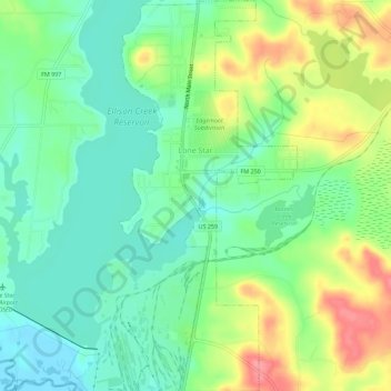
Name: Lone Star topographic map, elevation, terrain.

Location: Lone Star, Morris County, Texas, 75668, United States (32.91242 -94.72043 32.95964 -94.69480)

Average elevation: 335 ft

Minimum elevation: 230 ft

Maximum elevation: 518 ft

Morris County trails, hiking, mountain biking, running and outdoor activities

Other topographic maps

Click on a map to view its topography, its elevation and its terrain.

Cason

United States > Texas > Morris County

Average elevation: 318 ft

Gear up for your next adventure:

👖Convertible Hiking Pants - Versatile zip-off pants for changing altitudes and temperatures
🌎3D Topographic Globes - Raised relief globes for a tactile understanding of geography
🔭Stargazing Telescopes - Perfect for camping in low-light pollution areas shown on maps
📡GPS Antenna Upgrade - Enhance GPS reception in remote terrain
🗺️Topographic Maps - Detailed topo maps for hiking, exploring and outdoor navigation

As an Amazon Associate, this site earns from qualifying purchases at no extra cost to you.