
Zarzis topographic map
Interactive map
Click on the map to display elevation.
About this map
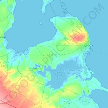
Name: Zarzis topographic map, elevation, terrain.
Location: Zarzis, Médenine, Tunisie (33.27721 10.75001 33.65490 11.29415)
Average elevation: 39 ft
Minimum elevation: -23 ft
Maximum elevation: 299 ft
Other topographic maps
Click on a map to view its topography, its elevation and its terrain.
El Mahboubine
El Mahboubine, Djerba Midoun, Médenine, 4165, Tunisie
Average elevation: 69 ft
Parc National Sidi Toui
Parc National Sidi Toui, El Amria, Ben Guerdane, Médenine, Tunisie
Average elevation: 341 ft