Geolocate

Fruitport topographic map

Click on the map to display elevation.

About this map

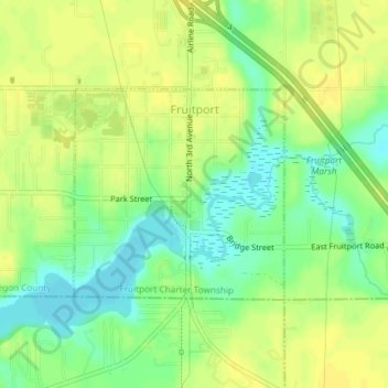
Name: Fruitport topographic map, elevation, terrain.

Location: Fruitport, Fruitport Charter Township, Muskegon County, Michigan, United States (43.11740 -86.16622 43.13210 -86.14611)

Average elevation: 620 ft

Minimum elevation: 577 ft

Maximum elevation: 650 ft

Muskegon County trails, hiking, mountain biking, running and outdoor activities

Other topographic maps

Click on a map to view its topography, its elevation and its terrain.

Maple Grove

United States > Michigan > Muskegon County > Montague

Average elevation: 620 ft

Patterson Park

United States > Michigan > Muskegon County

Average elevation: 679 ft

Gear up for your next adventure:

🔥Camping Stove - Portable stove for camping and backcountry cooking
🔭Compact Binoculars - HD vision for scouting terrain and identifying distant landmarks
📡GPS Antenna Upgrade - Enhance GPS reception in remote terrain
👓Polarized Sunglasses - Outdoor sunglasses for glare reduction
👖Convertible Hiking Pants - Versatile zip-off pants for changing altitudes and temperatures

As an Amazon Associate, this site earns from qualifying purchases at no extra cost to you.