Geolocate

Bugo topographic map

Click on the map to display elevation.

About this map

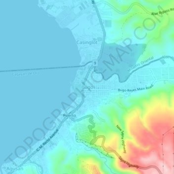
Name: Bugo topographic map, elevation, terrain.

Location: Bugo, Cagayan de Oro, Northern Mindanao, 9000, Philippines (8.48744 124.73478 8.52744 124.77478)

Average elevation: 141 ft

Minimum elevation: -3 ft

Maximum elevation: 853 ft

Other topographic maps

Click on a map to view its topography, its elevation and its terrain.

Calaanan Creek

Philippines > Cagayan de Oro

Average elevation: 230 ft

Gear up for your next adventure:

📌Outdoor GPS Map App - Apps and devices for digital topographic navigation
Backpacking Tent - Lightweight and durable tent for multi‑day hikes
🪶Survival Guide Book - Expert advice for emergency preparedness
🪶Trail Camera - Capture wildlife on your hikes
🔥Fast-Boil Camping Stoves - Efficient cooking systems for quick trail meals

As an Amazon Associate, this site earns from qualifying purchases at no extra cost to you.