Geolocate

Millington topographic map

Click on the map to display elevation.

About this map

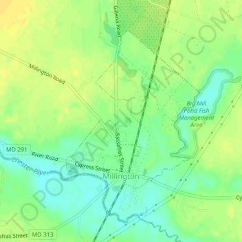
Name: Millington topographic map, elevation, terrain.

Location: Millington, Kent County, Maryland, United States (39.25410 -75.84506 39.27446 -75.82583)

Average elevation: 39 ft

Minimum elevation: 0 ft

Maximum elevation: 72 ft

Kent County trails, hiking, mountain biking, running and outdoor activities

Other topographic maps

Click on a map to view its topography, its elevation and its terrain.

Kennedyville

United States > Maryland > Kent County

Average elevation: 59 ft

Gear up for your next adventure:

🚪Portable Camp Chair - Foldable chair for comfort at camp
🔦LED Headlamp - Bright and durable LED headlamp for night navigation
🗺️NatGeo Topo Maps - High-quality waterproof printed topographic maps of US Parks
🔋Rechargeable Batteries - Power up your outdoor devices
🎒Waterproof Dry Bags - Keep your electronics and maps dry inside your pack

As an Amazon Associate, this site earns from qualifying purchases at no extra cost to you.