
Make a donation
Gear up for your next adventure:
As an Amazon Associate, this site earns from qualifying purchases at no extra cost to you.
Lac de Beuil topographic map
Click on the map to display elevation.
Make a donation
Gear up for your next adventure:
As an Amazon Associate, this site earns from qualifying purchases at no extra cost to you.
About this map
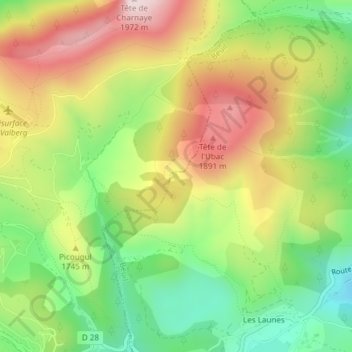
Name: Lac de Beuil topographic map, elevation, terrain.
Average elevation: 5,574 ft
Minimum elevation: 4,820 ft
Maximum elevation: 6,450 ft
Make a donation
Gear up for your next adventure:
As an Amazon Associate, this site earns from qualifying purchases at no extra cost to you.
Other topographic maps
Click on a map to view its topography, its elevation and its terrain.
Mont Mounier
France > Provence-Alpes-Côte d'Azur > Alpes-Maritimes > Beuil
Average elevation: 7,789 ft
Mont Brussière
France > Provence-Alpes-Côte d'Azur > Alpes-Maritimes > Beuil
Average elevation: 5,581 ft
Bergians Soubran
France > Provence-Alpes-Côte d'Azur > Alpes-Maritimes > Beuil
Average elevation: 5,131 ft
Make a donation
Gear up for your next adventure:
As an Amazon Associate, this site earns from qualifying purchases at no extra cost to you.
Gorges du Cians
France > Provence-Alpes-Côte d'Azur > Alpes-Maritimes > Beuil
Average elevation: 4,790 ft
Bergians Soutran
France > Provence-Alpes-Côte d'Azur > Alpes-Maritimes > Beuil
Average elevation: 5,098 ft
Make a donation
Gear up for your next adventure:
As an Amazon Associate, this site earns from qualifying purchases at no extra cost to you.
Mont Mounier
France > Provence-Alpes-Côte d'Azur > Alpes-Maritimes > Beuil
Average elevation: 7,789 ft