
Thank you for supporting this site ❤️
Make a donation
Make a donation
Gear up for your next adventure:
As an Amazon Associate, this site earns from qualifying purchases at no extra cost to you.
Calcena topographic map
Click on the map to display elevation.
Thank you for supporting this site ❤️
Make a donation
Make a donation
Gear up for your next adventure:
As an Amazon Associate, this site earns from qualifying purchases at no extra cost to you.
About this map
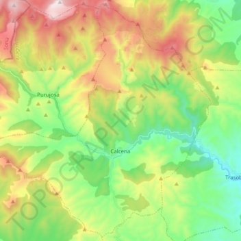
Name: Calcena topographic map, elevation, terrain.
Location: Calcena, Aranda, Saragosse, Aragon, Espagne (41.61409 -1.81311 41.72537 -1.65955)
Average elevation: 3,468 ft
Minimum elevation: 2,123 ft
Maximum elevation: 5,653 ft
Thank you for supporting this site ❤️
Make a donation
Make a donation
Gear up for your next adventure:
As an Amazon Associate, this site earns from qualifying purchases at no extra cost to you.
Other topographic maps
Click on a map to view its topography, its elevation and its terrain.
Aranda de Moncayo
Espagne > Aragon > Aranda > Aranda de Moncayo > Aranda de Moncayo
Average elevation: 2,904 ft