
Make a donation
Gear up for your next adventure:
As an Amazon Associate, this site earns from qualifying purchases at no extra cost to you.
Aragua State topographic map
Click on the map to display elevation.
Make a donation
Gear up for your next adventure:
As an Amazon Associate, this site earns from qualifying purchases at no extra cost to you.
Aragua State
Due to its diversity in relief and altitudes that it possesses in all its extension, there are different thermal floors in which the temperature tends to have different climatic characteristics and temperatures that decrease with the increase of the altitude, in the coastal strip dominates a semi-arid and warm climate, as it is evidenced in Turiamo and Puerto Maya, Although orographic rainfall occurs at elevations on the northern flank of the Serranía de Litoral, allowing for cooler and more humid conditions, which make possible the formation of cloud forests in the Henri Pittier National Park, local conditions allow for greater humidity and warmer temperatures in some coastal coves, such as Chuao, Choroní and Ocumare, which are used in traditional cocoa plantations.
Make a donation
Gear up for your next adventure:
As an Amazon Associate, this site earns from qualifying purchases at no extra cost to you.
About this map
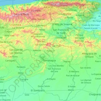
Name: Aragua State topographic map, elevation, terrain.
Location: Aragua State, Venezuela (9.24451 -67.88161 10.59585 -66.54644)
Average elevation: 1,549 ft
Minimum elevation: 0 ft
Maximum elevation: 8,747 ft
Make a donation
Gear up for your next adventure:
As an Amazon Associate, this site earns from qualifying purchases at no extra cost to you.
Other topographic maps
Click on a map to view its topography, its elevation and its terrain.
Make a donation
Gear up for your next adventure:
As an Amazon Associate, this site earns from qualifying purchases at no extra cost to you.