
Make a donation
Gear up for your next adventure:
As an Amazon Associate, this site earns from qualifying purchases at no extra cost to you.
La Maná topographic map
Click on the map to display elevation.
Make a donation
Gear up for your next adventure:
As an Amazon Associate, this site earns from qualifying purchases at no extra cost to you.
About this map
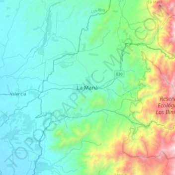
Name: La Maná topographic map, elevation, terrain.
Location: La Maná, Cotopaxi, 050202, Ecuador (-1.10104 -79.38504 -0.78104 -79.06504)
Average elevation: 1,860 ft
Minimum elevation: 217 ft
Maximum elevation: 8,550 ft
Make a donation
Gear up for your next adventure:
As an Amazon Associate, this site earns from qualifying purchases at no extra cost to you.
Other topographic maps
Click on a map to view its topography, its elevation and its terrain.
La Maná
La Maná es una ciudad ecuatoriana; cabecera cantonal del Cantón La Maná, así como la segunda urbe más grande y poblada de la Provincia de Cotopaxi. Se localiza al centro-norte de la región interandina del Ecuador, en los flancos externos de la cordillera occidental de los Andes, atravesada por el río…
Average elevation: 1,115 ft
Make a donation
Gear up for your next adventure:
As an Amazon Associate, this site earns from qualifying purchases at no extra cost to you.