
Bujumbura Mairie topographic map
Interactive map
Click on the map to display elevation.
About this map
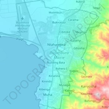
Name: Bujumbura Mairie topographic map, elevation, terrain.
Location: Bujumbura Mairie, Burundi (-3.44496 29.28880 -3.30012 29.42182)
Average elevation: 2,976 ft
Minimum elevation: 2,513 ft
Maximum elevation: 5,909 ft
Other topographic maps
Click on a map to view its topography, its elevation and its terrain.
Buterere
Burundi > Bujumbura Mairie > Buterere
Buterere, Bujumbura Mairie, 331, Burundi
Average elevation: 2,589 ft