
Notre-Dame-de-Lorette topographic map
Interactive map
Click on the map to display elevation.
About this map
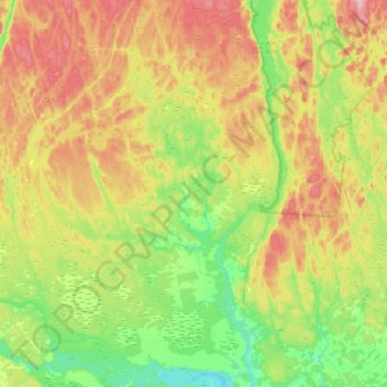
Name: Notre-Dame-de-Lorette topographic map, elevation, terrain.
Average elevation: 709 ft
Minimum elevation: 466 ft
Maximum elevation: 1,047 ft
Other topographic maps
Click on a map to view its topography, its elevation and its terrain.
Albanel
Canada > Quebec > Maria-Chapdelaine
Albanel, Maria-Chapdelaine, Saguenay–Lac-Saint-Jean, Quebec, G8M 3J0, Canada
Average elevation: 515 ft
Péribonka
Canada > Quebec > Maria-Chapdelaine
Péribonka, Maria-Chapdelaine, Saguenay–Lac-Saint-Jean, Quebec, G0W 2G0, Canada
Average elevation: 410 ft
Rivière aux Rats
Canada > Quebec > Maria-Chapdelaine > Rivière-Mistassini
Rivière aux Rats, Rivière-Mistassini, Maria-Chapdelaine, Saguenay–Lac-Saint-Jean, Quebec, Canada
Average elevation: 814 ft
Girardville
Canada > Quebec > Maria-Chapdelaine
Girardville, Maria-Chapdelaine, Saguenay–Lac-Saint-Jean, Quebec, G0W 1R0, Canada
Average elevation: 696 ft
Passes-Dangereuses
Canada > Quebec > Maria-Chapdelaine > Passes-Dangereuses
Passes-Dangereuses, Maria-Chapdelaine, Saguenay–Lac-Saint-Jean, Quebec, Canada
Average elevation: 1,598 ft
Normandin
Canada > Quebec > Maria-Chapdelaine
Normandin, Maria-Chapdelaine, Saguenay–Lac-Saint-Jean, Quebec, G8M 3Y1, Canada
Average elevation: 489 ft
Saint-Thomas-Didyme
Canada > Quebec > Maria-Chapdelaine
Saint-Thomas-Didyme, Maria-Chapdelaine, Saguenay–Lac-Saint-Jean, Quebec, Canada
Average elevation: 722 ft