
Thank you for supporting this site ❤️
Make a donation
Make a donation
Gear up for your next adventure:
As an Amazon Associate, this site earns from qualifying purchases at no extra cost to you.
Costalunga topographic map
Click on the map to display elevation.
Thank you for supporting this site ❤️
Make a donation
Make a donation
Gear up for your next adventure:
As an Amazon Associate, this site earns from qualifying purchases at no extra cost to you.
About this map
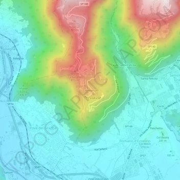
Name: Costalunga topographic map, elevation, terrain.
Location: Costalunga, Romano d'Ezzelino, Vicenza, Veneto, 35061, Italia (45.78750 11.72409 45.82750 11.76409)
Average elevation: 1,168 ft
Minimum elevation: 371 ft
Maximum elevation: 3,228 ft
Thank you for supporting this site ❤️
Make a donation
Make a donation
Gear up for your next adventure:
As an Amazon Associate, this site earns from qualifying purchases at no extra cost to you.