
Make a donation
Gear up for your next adventure:
As an Amazon Associate, this site earns from qualifying purchases at no extra cost to you.
Langdale Knott topographic map
Click on the map to display elevation.
Make a donation
Gear up for your next adventure:
As an Amazon Associate, this site earns from qualifying purchases at no extra cost to you.
About this map
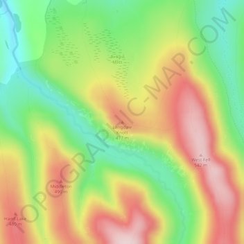
Name: Langdale Knott topographic map, elevation, terrain.
Average elevation: 1,266 ft
Minimum elevation: 768 ft
Maximum elevation: 1,811 ft
Make a donation
Gear up for your next adventure:
As an Amazon Associate, this site earns from qualifying purchases at no extra cost to you.
Other topographic maps
Click on a map to view its topography, its elevation and its terrain.
Barrow-in-Furness
United Kingdom > England > Westmorland and Furness > Askam-in-Furness
Average elevation: 72 ft
Make a donation
Gear up for your next adventure:
As an Amazon Associate, this site earns from qualifying purchases at no extra cost to you.
Toddygill Plantation
United Kingdom > England > Westmorland and Furness > Warcop
Average elevation: 564 ft