Geolocate

Quartzite topographic map

Click on the map to display elevation.

About this map

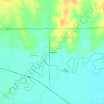
Name: Quartzite topographic map, elevation, terrain.

Location: Quartzite, Lincoln County, Kansas, United States (39.00112 -98.11477 39.04112 -98.07477)

Average elevation: 1,371 ft

Minimum elevation: 1,332 ft

Maximum elevation: 1,460 ft

Other topographic maps

Click on a map to view its topography, its elevation and its terrain.

Sylvan Grove

United States > Kansas > Lincoln County

Average elevation: 1,463 ft

Gear up for your next adventure:

🛡️Bear Spray Outdoor - Protection in bear country hikes
🌡️Handheld Weather Meters - Measure wind, temp, and pressure for safe mountain travel
💧Water Purification System - Clean water on the trail with reliable purifiers
🧣Hiking Neck Gaiter - Multi‑use neck protection for outdoor weather
🪶Camping Sleeping Pad - Comfortable sleeping pad for backpacking

As an Amazon Associate, this site earns from qualifying purchases at no extra cost to you.