
Make a donation
Gear up for your next adventure:
As an Amazon Associate, this site earns from qualifying purchases at no extra cost to you.
Réunion topographic map
Click on the map to display elevation.
Make a donation
Gear up for your next adventure:
As an Amazon Associate, this site earns from qualifying purchases at no extra cost to you.
Réunion
Already at the time of the India Route or Route des Indes, Réunion was a French possession located between Cape Town and the Indian trading posts, although far from the Mozambique Channel. Île de Bourbon (its name under the Ancien Régime) was not, however, the preferred position for trade and military. Governor Labourdonnais claimed that Île de France (Mauritius) was a land of opportunity, thanks to its topography and the presence of two natural harbours. He intended Île de Bourbon to be a depot or an emergency base for Île de France.
Make a donation
Gear up for your next adventure:
As an Amazon Associate, this site earns from qualifying purchases at no extra cost to you.
About this map
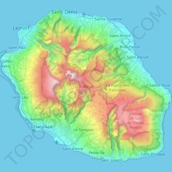
Name: Réunion topographic map, elevation, terrain.
Location: Réunion, France (-21.38971 55.21643 -20.87174 55.83669)
Average elevation: 1,745 ft
Minimum elevation: 0 ft
Maximum elevation: 9,984 ft
Make a donation
Gear up for your next adventure:
As an Amazon Associate, this site earns from qualifying purchases at no extra cost to you.
Other topographic maps
Click on a map to view its topography, its elevation and its terrain.
Mont Ventoux
France > Provence-Alpes-Côte d'Azur > Vaucluse > Saint-Léger-du-Ventoux
There are two small ski stations on the mountain: "Mont Serein" on the north side, and "Chalet Reynard" on the south. High winds and the modest elevation tend to limit the ski season. Weather conditions are such that the northern slope is often icy, leading to a saying among people of the surrounding region…
Average elevation: 5,108 ft
Make a donation
Gear up for your next adventure:
As an Amazon Associate, this site earns from qualifying purchases at no extra cost to you.
Make a donation
Gear up for your next adventure:
As an Amazon Associate, this site earns from qualifying purchases at no extra cost to you.
Curebouteille
France > Nouvelle-Aquitaine > Haute-Vienne > Oradour-sur-Vayres
Average elevation: 1,024 ft
Make a donation
Gear up for your next adventure:
As an Amazon Associate, this site earns from qualifying purchases at no extra cost to you.
Make a donation
Gear up for your next adventure:
As an Amazon Associate, this site earns from qualifying purchases at no extra cost to you.
Ruines du Barrage de Malpasset
France > Provence-Alpes-Côte d'Azur > Var > Fréjus
Average elevation: 387 ft
Make a donation
Gear up for your next adventure:
As an Amazon Associate, this site earns from qualifying purchases at no extra cost to you.
La Brugere
France > Auvergne-Rhône-Alpes > Puy-de-Dôme > Champagnat-le-Jeune
Average elevation: 2,051 ft
Make a donation
Gear up for your next adventure:
As an Amazon Associate, this site earns from qualifying purchases at no extra cost to you.
Make a donation
Gear up for your next adventure:
As an Amazon Associate, this site earns from qualifying purchases at no extra cost to you.
Les Ravineaux
France > Centre-Val de Loire > Indre > Villentrois-Faverolles-en-Berry
Average elevation: 430 ft
Make a donation
Gear up for your next adventure:
As an Amazon Associate, this site earns from qualifying purchases at no extra cost to you.
Lavaud-Bousquet
France > Nouvelle-Aquitaine > Haute-Vienne > Château-Chervix
Average elevation: 1,365 ft
Argentière
France > Auvergne-Rhône-Alpes > Upper Savoy > Chamonix-Mont-Blanc
Argentière (French pronunciation: [aʁʒɑ̃tjɛʁ]) is a picturesque skiing, alpine walking and mountaineering village in the French Alps, part of the commune of Chamonix-Mont-Blanc, at an altitude of 1,252 m (4,108 ft).
Average elevation: 5,492 ft
Make a donation
Gear up for your next adventure:
As an Amazon Associate, this site earns from qualifying purchases at no extra cost to you.
Le Tilleul - Antifer
France > Normandy > Seine-Maritime > La Poterie-Cap-d'Antifer
Average elevation: 138 ft
Make a donation
Gear up for your next adventure:
As an Amazon Associate, this site earns from qualifying purchases at no extra cost to you.
Make a donation
Gear up for your next adventure:
As an Amazon Associate, this site earns from qualifying purchases at no extra cost to you.
Méribel-Mottaret
France > Auvergne-Rhône-Alpes > Savoy > Les Allues > Méribel-Mottaret
Average elevation: 6,601 ft
Collonges
France > Auvergne-Rhône-Alpes > Upper Savoy > Vétraz-Monthoux > Collonges
Average elevation: 1,565 ft
Make a donation
Gear up for your next adventure:
As an Amazon Associate, this site earns from qualifying purchases at no extra cost to you.
Make a donation
Gear up for your next adventure:
As an Amazon Associate, this site earns from qualifying purchases at no extra cost to you.
Make a donation
Gear up for your next adventure:
As an Amazon Associate, this site earns from qualifying purchases at no extra cost to you.
Les Ansaults
France > Centre-Loire Valley > Indre-et-Loire > Artannes-sur-Indre > Les Ansaults
Average elevation: 240 ft
Les Clausonnes
France > Provence-Alpes-Côte d'Azur > Maritime Alps > Valbonne > Les Clausonnes
Average elevation: 489 ft
Make a donation
Gear up for your next adventure:
As an Amazon Associate, this site earns from qualifying purchases at no extra cost to you.