Geolocate

Florac topographic map

Click on the map to display elevation.

About this map

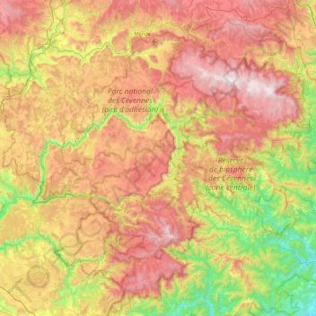
Name: Florac topographic map, elevation, terrain.

Location: Florac, Lozère, Occitania, Metropolitan France, France (44.10934 3.12019 44.44189 3.97699)

Average elevation: 2,792 ft

Minimum elevation: 472 ft

Maximum elevation: 5,574 ft

Other topographic maps

Click on a map to view its topography, its elevation and its terrain.

Sauveplane

France > Occitania > Lozère

Average elevation: 1,519 ft

Les Vanels

France > Occitania > Lozère > Vebron

Average elevation: 2,667 ft

Le Coustat

France > Occitania > Lozère > Nasbinals

Average elevation: 3,944 ft

Cassagnes

France > Occitania > Lozère > Saint-Pierre-des-Tripiers > Cassagnes

Average elevation: 2,362 ft

Biffares

France > Occitania > Lozère > Saint-Alban-sur-Limagnole

Average elevation: 3,225 ft

Lespartis

France > Occitania > Lozère > Peyre en Aubrac > Aumont-Aubrac

Average elevation: 3,435 ft

La Roche

France > Occitania > Lozère > Lajo

Average elevation: 4,006 ft

La Bastide

France > Occitania > Lozère > La Bastide-Puylaurent

Average elevation: 3,556 ft

Gear up for your next adventure:

🪶LED Camping Lantern - Bright lantern for camp lighting
🔦LED Headlamp - Bright and durable LED headlamp for night navigation
📶Satellite Messenger - Communication device off‑grid
🥩Freeze-Dried Meals - Nutritious and lightweight food for remote expeditions
🩳Quick‑Dry Hiking Shorts - Comfortable and quick‑dry shorts for summer hiking

As an Amazon Associate, this site earns from qualifying purchases at no extra cost to you.