
Make a donation
Gear up for your next adventure:
As an Amazon Associate, this site earns from qualifying purchases at no extra cost to you.
Ourjout topographic map
Click on the map to display elevation.
Make a donation
Gear up for your next adventure:
As an Amazon Associate, this site earns from qualifying purchases at no extra cost to you.
About this map
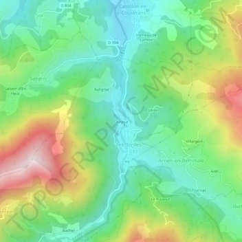
Name: Ourjout topographic map, elevation, terrain.
Average elevation: 2,546 ft
Minimum elevation: 1,693 ft
Maximum elevation: 4,154 ft
Make a donation
Gear up for your next adventure:
As an Amazon Associate, this site earns from qualifying purchases at no extra cost to you.
Other topographic maps
Click on a map to view its topography, its elevation and its terrain.
Uchentein
France > Occitanie > Ariège > Bordes-Uchentein
Ces carrières de marbre, d'accès difficile, sont situées à 1 215 m d'altitude. Il en était extrait des blocs taillés avec des câbles d'acier, pesant jusqu'à 14 tonnes. Descendus sur un chariot retenu par un câble, ils étaient ensuite transportés dans l'Hérault pour y être débités et polis.
Average elevation: 2,992 ft