Geolocate

Huber Heights topographic map

Interactive map

Click on the map to display elevation.

About this map

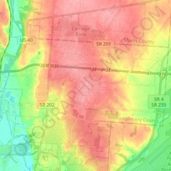
Name: Huber Heights topographic map, elevation, terrain.

Location: Huber Heights, Montgomery County, Ohio, 45424, United States (39.81835 -84.17546 39.89916 -84.05101)

Average elevation: 899 ft

Minimum elevation: 741 ft

Maximum elevation: 1,014 ft

Montgomery County trails, hiking, mountain biking, running and outdoor activities

Other topographic maps

Click on a map to view its topography, its elevation and its terrain.

Fort McKinley

United States > Ohio > Montgomery County > Dayton

Average elevation: 896 ft

Bridgeport

United States > Ohio > Montgomery County > Miamisburg

Average elevation: 797 ft

Patterson

United States > Ohio > Montgomery County > Dayton

Average elevation: 764 ft

Oakland

United States > Ohio > Montgomery County > Dayton

Average elevation: 883 ft

Dayton

United States > Ohio > Montgomery County > Dayton

Average elevation: 886 ft

North Riverdale

United States > Ohio > Montgomery County > Dayton

Average elevation: 833 ft

Shakertown

United States > Ohio > Montgomery County > Kettering

Average elevation: 925 ft

Hearthstone

United States > Ohio > Montgomery County > Dayton

Average elevation: 896 ft