Geolocate

Itasca State Park topographic map

Click on the map to display elevation.

About this map
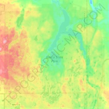
Name: Itasca State Park topographic map, elevation, terrain.

Location: Itasca State Park, Clearwater County, Minnesota, United States (47.13563 -95.29737 47.25020 -95.14141)

Average elevation: 1,585 ft

Minimum elevation: 1,411 ft

Maximum elevation: 1,831 ft

Clearwater County trails, hiking, mountain biking, running and outdoor activities

Other topographic maps

Click on a map to view its topography, its elevation and its terrain.

Long Lost Lake

United States > Minnesota > Clearwater County

Average elevation: 1,660 ft

Bagley

United States > Minnesota > Clearwater County

Average elevation: 1,460 ft

Lake Itasca

United States > Minnesota > Clearwater County

Average elevation: 1,519 ft

Lake Itasca

United States > Minnesota > Clearwater County

Average elevation: 1,519 ft

Bagley

United States > Minnesota > Clearwater County

Average elevation: 1,460 ft

Leonard

United States > Minnesota > Clearwater County > Leonard

Average elevation: 1,444 ft

Clearbrook

United States > Minnesota > Clearwater County

Average elevation: 1,345 ft

Gear up for your next adventure:

👟Men's Trail Runners - Lightweight footwear for fast-paced exploration and light hiking
⌚GPS Sports Watch - GPS watch for running, hiking and training
🧷Carabiner Set - Durable clips for gear attachment
☕Camping Coffee Makers - Enjoy premium coffee at the summit or campsite
🧥Waterproof Jacket for Hiking - Breathable and rugged rain jacket for outdoor excursions

As an Amazon Associate, this site earns from qualifying purchases at no extra cost to you.