
Make a donation
Gear up for your next adventure:
As an Amazon Associate, this site earns from qualifying purchases at no extra cost to you.
La Cabaña topographic map
Click on the map to display elevation.
Make a donation
Gear up for your next adventure:
As an Amazon Associate, this site earns from qualifying purchases at no extra cost to you.
About this map
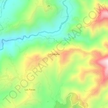
Name: La Cabaña topographic map, elevation, terrain.
Average elevation: 4,154 ft
Minimum elevation: 3,278 ft
Maximum elevation: 5,423 ft
Make a donation
Gear up for your next adventure:
As an Amazon Associate, this site earns from qualifying purchases at no extra cost to you.
Other topographic maps
Click on a map to view its topography, its elevation and its terrain.
Comuna Atardeceres
Colombia > Caldas > Manizales > Perímetro Urbano Manizales
Average elevation: 6,276 ft
Comuna Ecoturística Cerro de Oro
Colombia > Caldas > Manizales > Perímetro Urbano Manizales
Average elevation: 7,133 ft
Comuna San José
Colombia > Caldas > Manizales > Perímetro Urbano Manizales
Average elevation: 6,798 ft
Make a donation
Gear up for your next adventure:
As an Amazon Associate, this site earns from qualifying purchases at no extra cost to you.
Comuna Universitaria
Colombia > Caldas > Manizales > Perímetro Urbano Manizales
Average elevation: 6,486 ft
Comuna Ecoturística Cerro de Oro
Colombia > Caldas > Manizales > Perímetro Urbano Manizales
Average elevation: 7,133 ft
Comuna Ecoturística Cerro de Oro
Colombia > Caldas > Manizales > Perímetro Urbano Manizales
Average elevation: 7,133 ft
Comuna Tesorito
Colombia > Caldas > Manizales > Perímetro Urbano Manizales
Average elevation: 7,421 ft
Make a donation
Gear up for your next adventure:
As an Amazon Associate, this site earns from qualifying purchases at no extra cost to you.
Comuna Universitaria
Colombia > Caldas > Manizales > Perímetro Urbano Manizales
Average elevation: 6,486 ft