Geolocate

Badtucon topographic map

Click on the map to display elevation.

About this map

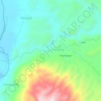
Name: Badtucon topographic map, elevation, terrain.

Location: Badtucon, Kiaring, North Cotabato, Soccsksargen, Philippines (7.35461 124.64858 7.39461 124.68858)

Average elevation: 965 ft

Minimum elevation: 341 ft

Maximum elevation: 2,530 ft

Gear up for your next adventure:

🧢Sun Protection Hats - Wide-brimmed and UPF-rated hats for high-altitude sun safety
GPS Sports Watch - GPS watch for running, hiking and training
😴Insulated Sleeping Pads - Compact and warm pads for high-elevation camping
🪶Paracord Bracelet - Survival bracelet with built‑in tools
💧Water Purification System - Clean water on the trail with reliable purifiers

As an Amazon Associate, this site earns from qualifying purchases at no extra cost to you.