
Grapeview topographic map
Interactive map
Click on the map to display elevation.
About this map
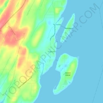
Name: Grapeview topographic map, elevation, terrain.
Location: Grapeview, Mason County, Washington, United States (47.31176 -122.85514 47.35176 -122.81514)
Average elevation: 69 ft
Minimum elevation: 0 ft
Maximum elevation: 266 ft
Other topographic maps
Click on a map to view its topography, its elevation and its terrain.
Matlock
United States > Washington > Mason County
Matlock, Mason County, Washington, 98560, United States
Average elevation: 436 ft
Triton
United States > Washington > Mason County
Triton, Mason County, Washington, United States
Average elevation: 400 ft
Belfair
United States > Washington > Mason County
Belfair, Mason County, Washington, United States
Average elevation: 207 ft
Shelton
United States > Washington > Mason County
Shelton, Mason County, Washington, United States
Average elevation: 177 ft
Harstine Island
United States > Washington > Mason County
Harstine Island, Mason County, Washington, United States
Average elevation: 98 ft
Lake Cushman
United States > Washington > Mason County
Lake Cushman, Mason County, Washington, United States
Average elevation: 1,332 ft
Lake Kokanee
United States > Washington > Mason County
Lake Kokanee, Mason County, Washington, United States
Average elevation: 705 ft
Lake Wooten
United States > Washington > Mason County
Lake Wooten, Mason County, Washington, United States
Average elevation: 427 ft
Allyn
United States > Washington > Mason County
Allyn, Mason County, Washington, 98524, United States
Average elevation: 148 ft
Hoodsport
United States > Washington > Mason County
Hoodsport, Mason County, Washington, 98548, United States
Average elevation: 203 ft
Shelton
United States > Washington > Mason County > Shelton > Shelton
Shelton, Mason County, Washington, United States
Average elevation: 180 ft
Lilliwaup
United States > Washington > Mason County > Lilliwaup
Lilliwaup, Mason County, Washington, United States
Average elevation: 374 ft
Tahuya
United States > Washington > Mason County
Tahuya, Mason County, Washington, 98588, United States
Average elevation: 161 ft