Geolocate

Matlock topographic map

Click on the map to display elevation.

About this map

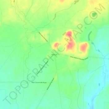
Name: Matlock topographic map, elevation, terrain.

Location: Matlock, Mason County, Washington, 98560, United States (47.21787 -123.42794 47.25787 -123.38794)

Average elevation: 436 ft

Minimum elevation: 351 ft

Maximum elevation: 581 ft

Mason County trails, hiking, mountain biking, running and outdoor activities

Other topographic maps

Click on a map to view its topography, its elevation and its terrain.

Shelton

United States > Washington > Mason County

Average elevation: 177 ft

Allyn

United States > Washington > Mason County > Allyn

Average elevation: 154 ft

Belfair

United States > Washington > Mason County

Average elevation: 213 ft

Oakland Bay

United States > Washington > Mason County > Shelton

Average elevation: 118 ft

Price Lake

United States > Washington > Mason County

Average elevation: 1,070 ft

Allyn

United States > Washington > Mason County > Allyn

Average elevation: 154 ft

Lake Cushman

United States > Washington > Mason County

Average elevation: 1,345 ft

Belfair

United States > Washington > Mason County

Average elevation: 213 ft

Grapeview

United States > Washington > Mason County

Average elevation: 56 ft

Gear up for your next adventure:

📶Satellite Messenger - Communication device off‑grid
🪶LED Camping Lantern - Bright lantern for camp lighting
📌Outdoor GPS Map App - Apps and devices for digital topographic navigation
🌎3D Topographic Globes - Raised relief globes for a tactile understanding of geography
🥾Hiking Shoes - Durable and comfortable shoes for trail hiking

As an Amazon Associate, this site earns from qualifying purchases at no extra cost to you.