Geolocate
👉 Easily get elevation data in JSON, GeoTIFF and KML formats using Elevation API
Thank you for supporting this site ❤️
Make a donation

Basseang topographic map

Click on the map to display elevation.

About this map

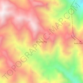
Name: Basseang topographic map, elevation, terrain.

Location: Basseang, Pinrang, South Sulawesi, Sulawesi, Indonesia (-3.38445 119.61415 -3.34445 119.65415)

Average elevation: 4,741 ft

Minimum elevation: 2,290 ft

Maximum elevation: 6,312 ft

Other topographic maps

Click on a map to view its topography, its elevation and its terrain.

Gear up for your next adventure:

🛰️Satellite Messengers - Emergency SOS and two-way messaging for off-grid adventures
Solar GPS Watches - Advanced multisport watches with built-in topographic maps
🧭Outdoor Navigation Book - Learn advanced navigation skills
🥤Water Filter Bottle - All‑in‑one filter bottle for safe hydration
🌲Outdoor Survival Books - Best books on survival skills

As an Amazon Associate, this site earns from qualifying purchases at no extra cost to you.