
Make a donation
Gear up for your next adventure:
As an Amazon Associate, this site earns from qualifying purchases at no extra cost to you.
Soglio topographic map
Click on the map to display elevation.
Make a donation
Gear up for your next adventure:
As an Amazon Associate, this site earns from qualifying purchases at no extra cost to you.
About this map
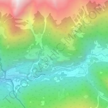
Name: Soglio topographic map, elevation, terrain.
Location: Soglio, Bregaglia, Maloja, Grisons, 7610, Switzerland (46.32207 9.51988 46.36207 9.55988)
Average elevation: 4,452 ft
Minimum elevation: 2,162 ft
Maximum elevation: 8,570 ft
Make a donation
Gear up for your next adventure:
As an Amazon Associate, this site earns from qualifying purchases at no extra cost to you.
Other topographic maps
Click on a map to view its topography, its elevation and its terrain.
Sankt Moritz
Switzerland > Grisons > Maloja
St. Moritz (also German: Sankt Moritz, Romansh: San Murezzan (help·info), Italian: San Maurizio, French: Saint-Moritz) is a high Alpine resort town in the Engadine in Switzerland, at an elevation of about 1,800 metres (5,910 ft) above sea level. It is Upper Engadine's major town and a municipality in the…
Average elevation: 7,129 ft
Sankt Moritz
Switzerland > Grisons > Maloja
St. Moritz (/ˌsæn məˈrɪts/ SAN mə-RITS, US also /ˌseɪnt -/ SAYNT -, UK also /sənt ˈmɒrɪts/ sənt MORR-its; German, in full: Sankt Moritz [zaŋkt moˈrɪts, ˈmoːrɪts] locally [saŋkt]; Romansh: San Murezzan [sam muˈʁetsən] ; Italian: San Maurizio; French: Saint-Moritz) is a high Alpine…
Average elevation: 7,129 ft
Pontresina
Switzerland > Grisons > Maloja
Before 2017, the municipality was located in the Oberengadin sub-district of the Maloja district, after 2017 it was part of the Maloja Region. It sits in Val Bernina, which is the highest altitude valley that branches off the Upper Engadin Valley. The municipality includes the highest mountain of the canton,…
Average elevation: 8,465 ft
Make a donation
Gear up for your next adventure:
As an Amazon Associate, this site earns from qualifying purchases at no extra cost to you.
Sankt Moritz
Switzerland > Grisons > Maloja
St. Moritz (/ˌsæn məˈrɪts/ SAN mə-RITS, US also /ˌseɪnt -/ SAYNT -, UK also /sənt ˈmɒrɪts/ sənt MORR-its; German, in full: Sankt Moritz [zaŋkt moˈrɪts, ˈmoːrɪts] locally [saŋkt]; Romansh: San Murezzan [sam muˈʁetsən] ; Italian: San Maurizio; French: Saint-Moritz) is a high Alpine…
Average elevation: 7,129 ft
Pontresina
Switzerland > Grisons > Maloja
Before 2017, the municipality was located in the Oberengadin sub-district of the Maloja district, after 2017 it was part of the Maloja Region. It sits in Val Bernina, which is the highest altitude valley that branches off the Upper Engadin Valley. The municipality includes the highest mountain of the canton,…
Average elevation: 8,465 ft
Make a donation
Gear up for your next adventure:
As an Amazon Associate, this site earns from qualifying purchases at no extra cost to you.
Make a donation
Gear up for your next adventure:
As an Amazon Associate, this site earns from qualifying purchases at no extra cost to you.
Lägh dal Lunghin
Switzerland > Grisons > Maloja
Lägh dal Lunghin (German: Lunghinsee) is a lake at an elevation of 2484 m, below the peak of Piz Lunghin, in the Graubünden, Switzerland. It is considered the source of the Inn River.
Average elevation: 8,058 ft