
Make a donation
Gear up for your next adventure:
As an Amazon Associate, this site earns from qualifying purchases at no extra cost to you.
Molamenqing topographic map
Click on the map to display elevation.
Make a donation
Gear up for your next adventure:
As an Amazon Associate, this site earns from qualifying purchases at no extra cost to you.
Molamenqing
Molamenqing, also known as Phola Gangchen, is an eastern outlier of Shishapangma, the 14th-highest peak in the world. Both are in the Jugal Himal, a subrange of the Himalaya in Tibet. (This range is contiguous with, and often considered a part of, the Langtang Himal.) Its elevation is also given as 7,661 m (25,135 ft); the elevation given here is from a Chinese survey. Molamenqing is little-known, partly since it does not have much independent stature. Its topographic prominence, i.e. its rise above the saddle connecting it with Shishapangma, is only 430 metres, which is relatively small for a Himalayan peak, although large enough for it to qualify in some reckonings as an independent peak.
Make a donation
Gear up for your next adventure:
As an Amazon Associate, this site earns from qualifying purchases at no extra cost to you.
About this map
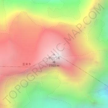
Name: Molamenqing topographic map, elevation, terrain.
Average elevation: 22,165 ft
Minimum elevation: 18,563 ft
Maximum elevation: 25,115 ft
Make a donation
Gear up for your next adventure:
As an Amazon Associate, this site earns from qualifying purchases at no extra cost to you.