
Make a donation
Gear up for your next adventure:
As an Amazon Associate, this site earns from qualifying purchases at no extra cost to you.
Signaal Imbosch topographic map
Click on the map to display elevation.
Make a donation
Gear up for your next adventure:
As an Amazon Associate, this site earns from qualifying purchases at no extra cost to you.
Signaal Imbosch
Signaal Imbosch is een heuvel van 109,9 meter hoogte (volgens de Rijksdriehoeksmeting) in de gemeente Rheden in het Nationaal Park Veluwezoom. Het is het hoogste punt van de Veluwe, van de provincie Gelderland en tevens het hoogste punt van het Europese deel van Nederland buiten Zuid-Limburg.
Make a donation
Gear up for your next adventure:
As an Amazon Associate, this site earns from qualifying purchases at no extra cost to you.
About this map
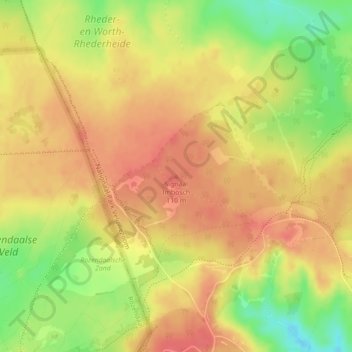
Name: Signaal Imbosch topographic map, elevation, terrain.
Average elevation: 282 ft
Minimum elevation: 157 ft
Maximum elevation: 348 ft
Make a donation
Gear up for your next adventure:
As an Amazon Associate, this site earns from qualifying purchases at no extra cost to you.
Other topographic maps
Click on a map to view its topography, its elevation and its terrain.