
Berlin topographic map
Click on the map to display elevation.
About this map
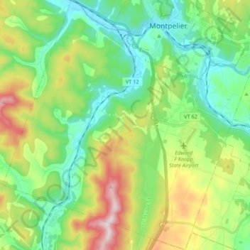
Name: Berlin topographic map, elevation, terrain.
Location: Berlin, Washington County, Vermont, United States (44.15478 -72.68368 44.27197 -72.51979)
Average elevation: 1,033 ft
Minimum elevation: 495 ft
Maximum elevation: 2,182 ft
Washington County trails, hiking, mountain biking, running and outdoor activities
Other topographic maps
Click on a map to view its topography, its elevation and its terrain.
Northfield Center
United States > Vermont > Washington County > Northfield
Average elevation: 1,119 ft
Northfield Center
United States > Vermont > Washington County > Northfield
Average elevation: 1,119 ft