Geolocate

Degana topographic map

Click on the map to display elevation.

Degana

Degana is located at 26°53′42″N 74°19′20″E / 26.895052°N 74.322166°E / 26.895052; 74.322166. It has an average elevation of 353 metres (1161 ft).

Wikipedia (CC-BY-SA 3.0)

About this map

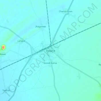
Name: Degana topographic map, elevation, terrain.

Location: Degana, Degana Tehsil, Nagaur, Rajasthan, 341503, India (26.85587 74.28225 26.93587 74.36225)

Average elevation: 1,125 ft

Minimum elevation: 1,089 ft

Maximum elevation: 1,522 ft

Gear up for your next adventure:

🧦Merino Wool Socks - Moisture-wicking, blister-preventing socks for long treks
🎒Outdoor Daypacks - Lightweight backpacks designed for carrying maps and essential gear
🪶Thermal Camp Blanket - Extra warmth for cold nights
🎒Gear Packing Cubes - Organize your backpack efficiently
🪶Camp Gear Gift Set - Perfect gift bundle for outdoor fans

As an Amazon Associate, this site earns from qualifying purchases at no extra cost to you.