Geolocate

Stephenville topographic map

Click on the map to display elevation.

About this map

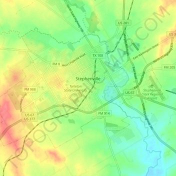
Name: Stephenville topographic map, elevation, terrain.

Location: Stephenville, Erath County, Texas, United States (32.18889 -98.26347 32.24118 -98.17313)

Average elevation: 1,319 ft

Minimum elevation: 1,204 ft

Maximum elevation: 1,480 ft

Erath County trails, hiking, mountain biking, running and outdoor activities

Other topographic maps

Click on a map to view its topography, its elevation and its terrain.

Bluff Dale

United States > Texas > Erath County

Average elevation: 948 ft

Morgan Mill

United States > Texas > Erath County

Average elevation: 1,083 ft

Yoho Park

United States > Texas > Erath County

Average elevation: 1,345 ft

Bluff Dale

United States > Texas > Erath County

Average elevation: 948 ft

Gear up for your next adventure:

🧢Sun Protection Hats - Wide-brimmed and UPF-rated hats for high-altitude sun safety
👓Polarized Sunglasses - Outdoor sunglasses for glare reduction
🧭Pro Hiking Compasses - High-accuracy liquid-filled compasses for topographic orientation
🛰️Handheld GPS Units - Professional satellite navigators for precise backcountry mapping
🧯Emergency Survival Kit - All‑in‑one survival essentials for the backcountry

As an Amazon Associate, this site earns from qualifying purchases at no extra cost to you.