Geolocate

Bluff Dale topographic map

Click on the map to display elevation.

About this map

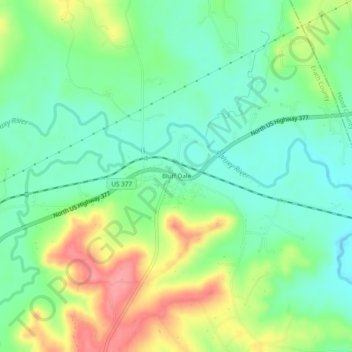
Name: Bluff Dale topographic map, elevation, terrain.

Location: Bluff Dale, Erath County, Texas, 76433, United States (32.33097 -98.04143 32.37097 -98.00143)

Average elevation: 948 ft

Minimum elevation: 837 ft

Maximum elevation: 1,138 ft

Erath County trails, hiking, mountain biking, running and outdoor activities

Other topographic maps

Click on a map to view its topography, its elevation and its terrain.

Stephenville

United States > Texas > Erath County

Average elevation: 1,319 ft

Dublin

United States > Texas > Erath County

Average elevation: 1,480 ft

Stephenville

United States > Texas > Erath County

Average elevation: 1,316 ft

Yoho Park

United States > Texas > Erath County

Average elevation: 1,345 ft

Stephenville

United States > Texas > Erath County

Average elevation: 1,316 ft

Gear up for your next adventure:

🏥Hiking First Aid Kits - Comprehensive medical kits for remote trail injuries
🥘Titanium Cookware - Durable, featherlight pots and pans for backpacking
📡GPS Antenna Upgrade - Enhance GPS reception in remote terrain
🧷Carabiner Set - Durable clips for gear attachment
🪶Thermal Camp Blanket - Extra warmth for cold nights

As an Amazon Associate, this site earns from qualifying purchases at no extra cost to you.