Geolocate

Kasol topographic map

Click on the map to display elevation.

About this map

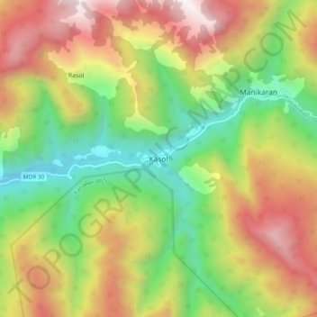
Name: Kasol topographic map, elevation, terrain.

Location: Kasol, Bhuntar, Kullu, Himachal Pradesh, India (31.97043 77.27660 32.05043 77.35660)

Average elevation: 7,953 ft

Minimum elevation: 4,747 ft

Maximum elevation: 11,965 ft

Gear up for your next adventure:

🪶Camping Sleeping Pad - Comfortable sleeping pad for backpacking
🕶️GPS Smartphone Mount - Secure mount for phone navigation
🛰️Satellite Messengers - Emergency SOS and two-way messaging for off-grid adventures
🪑Ultralight Camp Chairs - Portable seating for resting after a long day of mapping
💧Water Filtration Bottles - Safely drink from streams and lakes while exploring

As an Amazon Associate, this site earns from qualifying purchases at no extra cost to you.