
Make a donation
Gear up for your next adventure:
As an Amazon Associate, this site earns from qualifying purchases at no extra cost to you.
Bhandara City topographic map
Click on the map to display elevation.
Make a donation
Gear up for your next adventure:
As an Amazon Associate, this site earns from qualifying purchases at no extra cost to you.
Bhandara City
Bhandara is located at 21°10′N 79°39′E / 21.17°N 79.65°E / 21.17; 79.65 in the north-east part of the state. It has an average elevation of 244 metres (800 feet).
Make a donation
Gear up for your next adventure:
As an Amazon Associate, this site earns from qualifying purchases at no extra cost to you.
About this map
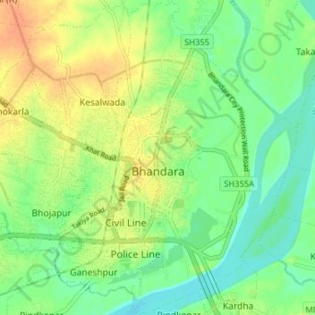
Name: Bhandara City topographic map, elevation, terrain.
Location: Bhandara City, Bhandara Taluka, Bhandara, Maharashtra, India (21.14292 79.63572 21.20357 79.68523)
Average elevation: 827 ft
Minimum elevation: 774 ft
Maximum elevation: 892 ft
Make a donation
Gear up for your next adventure:
As an Amazon Associate, this site earns from qualifying purchases at no extra cost to you.