
Make a donation
Gear up for your next adventure:
As an Amazon Associate, this site earns from qualifying purchases at no extra cost to you.
Oberlungwitz topographic map
Click on the map to display elevation.
Make a donation
Gear up for your next adventure:
As an Amazon Associate, this site earns from qualifying purchases at no extra cost to you.
About this map
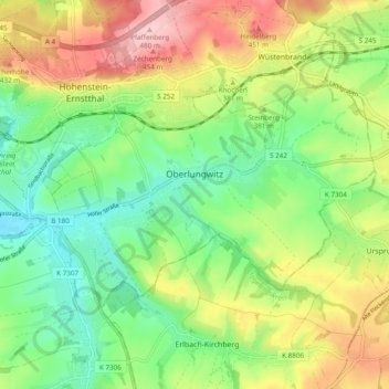
Name: Oberlungwitz topographic map, elevation, terrain.
Location: Oberlungwitz, Zwickau, Sachsen, 09353, Deutschland (50.76845 12.68277 50.80390 12.77886)
Average elevation: 1,207 ft
Minimum elevation: 955 ft
Maximum elevation: 1,578 ft
Make a donation
Gear up for your next adventure:
As an Amazon Associate, this site earns from qualifying purchases at no extra cost to you.
Other topographic maps
Click on a map to view its topography, its elevation and its terrain.
Mülsen
Deutschland > Sachsen > Zwickau
Zwischen Mülsen und Zwickau-Pöhlau liegt die „Mülsener Höhe“ auf einem Bergrücken, der parallel zum Mülsengrund verläuft, direkt an der Hauptstraße in Richtung Zwickau. Hier erinnert – direkt an einer Wegegabelung – ein Gedenkstein mit Inschrift an Ereignisse der Napoleonischen Kriege. Am 29.…
Average elevation: 1,119 ft
Make a donation
Gear up for your next adventure:
As an Amazon Associate, this site earns from qualifying purchases at no extra cost to you.
Make a donation
Gear up for your next adventure:
As an Amazon Associate, this site earns from qualifying purchases at no extra cost to you.
Make a donation
Gear up for your next adventure:
As an Amazon Associate, this site earns from qualifying purchases at no extra cost to you.
Thurm
Deutschland > Sachsen > Zwickau
Zwischen Mülsen und Zwickau-Pöhlau liegt die „Mülsener Höhe“ auf einem Bergrücken, der parallel zum Mülsengrund verläuft, direkt an der Hauptstraße in Richtung Zwickau. Hier erinnert – direkt an einer Wegegabelung – ein Gedenkstein mit Inschrift an Ereignisse der Napoleonischen Kriege. Am 29.…
Average elevation: 1,033 ft
Hartmannsdorf
Deutschland > Sachsen > Zwickau > Hartmannsdorf bei Kirchberg
Average elevation: 1,558 ft
Make a donation
Gear up for your next adventure:
As an Amazon Associate, this site earns from qualifying purchases at no extra cost to you.
FFH Mittleres Zwickauer Muldetal (Teilfläche 4: Wiese bei Bräunsdorf)
Deutschland > Sachsen > Zwickau > Limbach-Oberfrohna > Bräunsdorf
Average elevation: 1,070 ft
Make a donation
Gear up for your next adventure:
As an Amazon Associate, this site earns from qualifying purchases at no extra cost to you.
Make a donation
Gear up for your next adventure:
As an Amazon Associate, this site earns from qualifying purchases at no extra cost to you.
FFH Mittleres Zwickauer Muldetal (Teilfläche 2: Mulde südlich Glauchau)
Deutschland > Sachsen > Zwickau > Zwickau
Average elevation: 906 ft
Make a donation
Gear up for your next adventure:
As an Amazon Associate, this site earns from qualifying purchases at no extra cost to you.
Wüstenbrand
Deutschland > Sachsen > Zwickau > Hohenstein-Ernstthal
Wüstenbrand befindet sich östlich von Hohenstein-Ernstthal am „Rabensteiner Höhenzug“, der den Nordrand des Erzgebirgsbeckens vom Südrand des Mittelsächsischen Lößlehm-Hügellandes trennt. Nordwestlich von Wüstenbrand befindet sich das Landschaftsschutzgebiet „Pfaffenberg–Oberwald“ mit der…
Average elevation: 1,299 ft
Make a donation
Gear up for your next adventure:
As an Amazon Associate, this site earns from qualifying purchases at no extra cost to you.