Geolocate

Turi topographic map

Click on the map to display elevation.

About this map

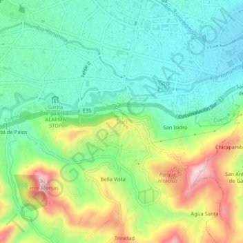
Name: Turi topographic map, elevation, terrain.

Location: Turi, Cuenca, Azuay, EC000000, Ecuador (-2.94247 -79.03009 -2.90247 -78.99009)

Average elevation: 8,547 ft

Minimum elevation: 8,156 ft

Maximum elevation: 9,327 ft

Gear up for your next adventure:

👟Trail Running Shoes - Lightweight shoes for trail runners
🌲Outdoor Survival Books - Best books on survival skills
🌐World Map Poster - Decorative world maps with topographic info
🥇GPS Hiking Watch - Multi‑sport GPS watch with navigation and trail tracking
🔥Plasma Lighters - Windproof lighters that work in any weather condition

As an Amazon Associate, this site earns from qualifying purchases at no extra cost to you.