Geolocate

Ceva topographic map

Click on the map to display elevation.

About this map

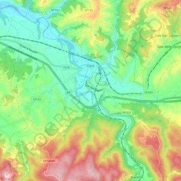
Name: Ceva topographic map, elevation, terrain.

Location: Ceva, Cuneo, Piemont, 12073, Italy (44.33876 7.98015 44.41476 8.08068)

Average elevation: 1,719 ft

Minimum elevation: 1,138 ft

Maximum elevation: 2,707 ft

Gear up for your next adventure:

🪄Magnetic Compass - Accurate compass for navigation
🔦Compact Flashlight - Reliable flashlight for emergencies
Camping Coffee Makers - Enjoy premium coffee at the summit or campsite
🦶Carbon Trekking Poles - Reduce knee impact on steep descents with ultra-light poles
🔥Plasma Lighters - Windproof lighters that work in any weather condition

As an Amazon Associate, this site earns from qualifying purchases at no extra cost to you.