
Make a donation
Gear up for your next adventure:
As an Amazon Associate, this site earns from qualifying purchases at no extra cost to you.
Badener Höhe topographic map
Click on the map to display elevation.
Make a donation
Gear up for your next adventure:
As an Amazon Associate, this site earns from qualifying purchases at no extra cost to you.
About this map
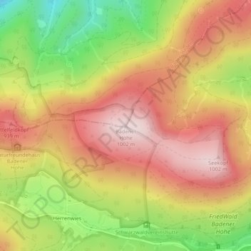
Name: Badener Höhe topographic map, elevation, terrain.
Average elevation: 2,697 ft
Minimum elevation: 1,919 ft
Maximum elevation: 3,284 ft
Make a donation
Gear up for your next adventure:
As an Amazon Associate, this site earns from qualifying purchases at no extra cost to you.
Other topographic maps
Click on a map to view its topography, its elevation and its terrain.
Schwarzenbachtalsperre
Deutschland > Baden-Württemberg > Landkreis Rastatt > Forbach
Der Stausee sammelt das Wasser am Ostabhang des niederschlagsreichen Hauptkamms des nördlichen Schwarzwalds, unterhalb von Hornisgrinde, Mehliskopf und Badener Höhe. Der Schwarzenbach und der Seebach werden direkt gestaut, das Wasser der Bäche Biberach und Hundsbach (Quellbäche der Raumünzach) wird per…
Average elevation: 2,293 ft