Geolocate

Maricao topographic map

Click on the map to display elevation.

About this map

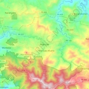
Name: Maricao topographic map, elevation, terrain.

Location: Maricao, Puerto Rico, 00606, United States (18.14076 -67.01979 18.22076 -66.93979)

Average elevation: 1,601 ft

Minimum elevation: 669 ft

Maximum elevation: 2,890 ft

Gear up for your next adventure:

🪶Survival Guide Book - Expert advice for emergency preparedness
🧯Emergency Survival Kit - All‑in‑one survival essentials for the backcountry
🛰️Satellite Messengers - Emergency SOS and two-way messaging for off-grid adventures
🌄Hiking Binoculars - Compact binoculars for scenic views and trail spotting
🪶Compact Camp Shovel - Folding shovel for campsite tasks

As an Amazon Associate, this site earns from qualifying purchases at no extra cost to you.