Geolocate

Chopine topographic map

Click on the map to display elevation.

About this map

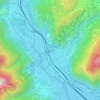
Name: Chopine topographic map, elevation, terrain.

Location: Chopine, Torille, Verrès, Aosta Valley, 11029, Italy (45.64984 7.66451 45.68984 7.70451)

Average elevation: 2,001 ft

Minimum elevation: 1,155 ft

Maximum elevation: 4,843 ft

Gear up for your next adventure:

📷Action Cameras - Rugged cameras to document your journeys across rugged terrain
📷Action Camera - Capture your outdoor adventures in HD
🧤Hiking Gloves - Protective gloves for rugged trails
🛠️Outdoor Gear Repair Kit - Essential tools to fix gear on the trail
🔦LED Headlamp - Bright and durable LED headlamp for night navigation

As an Amazon Associate, this site earns from qualifying purchases at no extra cost to you.