Geolocate

Jamestown topographic map

Click on the map to display elevation.

About this map

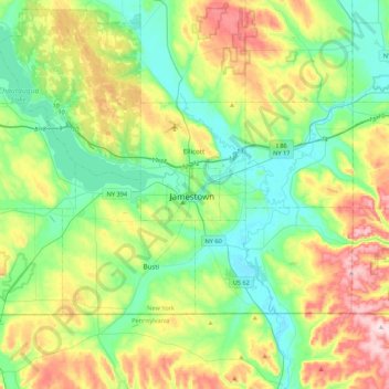
Name: Jamestown topographic map, elevation, terrain.

Location: Jamestown, Chautauqua County, New York, 14702, United States (41.93700 -79.39533 42.25700 -79.07533)

Average elevation: 1,549 ft

Minimum elevation: 1,220 ft

Maximum elevation: 2,244 ft

Chautauqua County trails, hiking, mountain biking, running and outdoor activities

Gear up for your next adventure:

🧭Compass with Lanyard - Easy‑carry compass for navigation
🧭Outdoor Navigation Book - Learn advanced navigation skills
🪶Multi‑Purpose Knife - Useful blade for camp and trail
🪶Compact Camp Shovel - Folding shovel for campsite tasks
🥾Men's Hiking Boots - Durable, waterproof footwear for rugged terrain and steep inclines

As an Amazon Associate, this site earns from qualifying purchases at no extra cost to you.