
Make a donation
Gear up for your next adventure:
As an Amazon Associate, this site earns from qualifying purchases at no extra cost to you.
Cumberland Gap topographic map
Click on the map to display elevation.
Make a donation
Gear up for your next adventure:
As an Amazon Associate, this site earns from qualifying purchases at no extra cost to you.
Cumberland Gap
The V-shaped gap serves as a gateway to the west. The base of the gap is about 300 ft (91 m) above the valley floor, even though the north side of the pass was lowered 20 ft (6.1 m) during the construction of Old U.S. Route 25E. To the south, the ridge rises 600 ft (180 m) above the pass, while to the north the Pinnacle Overlook towers 900 ft (270 m) above (elevation 2,505 ft (764 m)).
Make a donation
Gear up for your next adventure:
As an Amazon Associate, this site earns from qualifying purchases at no extra cost to you.
About this map
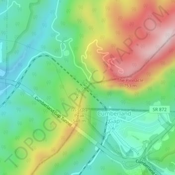
Name: Cumberland Gap topographic map, elevation, terrain.
Location: Cumberland Gap, Lee County, Virginia, 37724, United States (36.60399 -83.67369 36.60409 -83.67359)
Average elevation: 1,680 ft
Minimum elevation: 1,145 ft
Maximum elevation: 2,569 ft
Lee County trails, hiking, mountain biking, running and outdoor activities
Make a donation
Gear up for your next adventure:
As an Amazon Associate, this site earns from qualifying purchases at no extra cost to you.
Other topographic maps
Click on a map to view its topography, its elevation and its terrain.
Make a donation
Gear up for your next adventure:
As an Amazon Associate, this site earns from qualifying purchases at no extra cost to you.