
Make a donation
Gear up for your next adventure:
As an Amazon Associate, this site earns from qualifying purchases at no extra cost to you.
Eschweiler topographic map
Click on the map to display elevation.
Make a donation
Gear up for your next adventure:
As an Amazon Associate, this site earns from qualifying purchases at no extra cost to you.
Eschweiler
Die Fläche des Stadtgebiets beträgt 76,57 Quadratkilometer. Sie ist am weitesten in Ost-West-Ausdehnung (9,8 km) und in Nord-Süd-Ausdehnung (10,7 km). Der tiefste Punkt mit 110 m ü. NN liegt an der Inde bei Weisweiler, der höchste mit 262,5 m am Stadtwald; die mittlere Höhenlage, gemessen am Markt, beträgt 140 m.
Make a donation
Gear up for your next adventure:
As an Amazon Associate, this site earns from qualifying purchases at no extra cost to you.
About this map
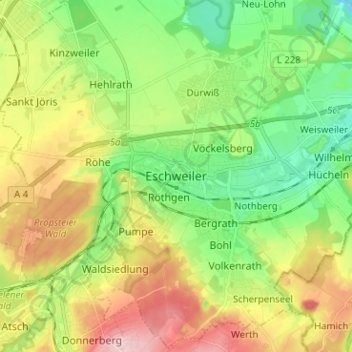
Name: Eschweiler topographic map, elevation, terrain.
Average elevation: 574 ft
Minimum elevation: 335 ft
Maximum elevation: 935 ft
Make a donation
Gear up for your next adventure:
As an Amazon Associate, this site earns from qualifying purchases at no extra cost to you.